
Stats first: 44.3Km (44.15 + the first ~150m until I
remembered to start my watch); 813m climb. 11:51:01h. Punched 49 out of 76
controls for 1,980 points (Top Veteran scored 2,050; so close…). 14th
out of 32 12h teams.
This was the second
year of this fantastic Rogaine, and eyeballing the number of participants, I
think it gained in popularity. This time there were 76 controls – 30
manually-punchable 10 pointers and 46 e-punches. Last year, I arrived late and
had less than 20 minutes to look at the three huge maps, resulting in a very
erratic, though still enjoyable, outing. This year, I had the chance to preplan
based on a grasp of the area from last year, and the result was a very good
outing.
Before even seeing the
map, I knew that I wanted to hit the Corn Maze around mid-race, as well as
cover the eastern part of the map, which I did not visit last year, so the
blind plan was to head NE while collecting high-value controls in the center
block along the way, and go clockwise: SE, S-Central, SW, W-central/Oak Hill,
NW and back. Ten-pointer controls will be treated as optional– collected only
if they made sense and integrated into the flow. When we got the maps, they
were definitely amenable to that plan. As usual, I charted a course-clearing
plan, with the clear notion that I will modify or bail to adjust for time as
the race progressed.

#65 was the only high-value control near the hash house, and
I knew I will be in crunch at the end, so the time to collect it was now. I
started cold and did not yet have my orienteering game on, but followed the
general south direction on the lawn and the large crowd that went there, and
found it where it should be.
#1C was smack on the way to 66, so I went for it first.
Still trying to get my bearings about me, I winged it and dived down two
reentrants too early, and just continued slope-side until the correct one.
To get to #66 I went back to the trail, then to the north
edge of the open field and from the NW corner of the parking lot made a
two-step approach – first, to the edge of the deep reentrant south of the
control, and then following the edge and peeking left for the reentrant with
the control. A female team and KJ Rufener were also looking for the control. Based
on the contours, I have a feeling that this control was placed one shallow
reentrant north of the deeper one at the center of the circle.
NE block
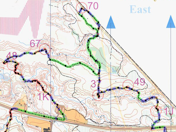
From 66, I followed
the edge of the steep reentrant SE, and crossed when the steepness subsided,
heading NNE to Rt. 303 crossing the stream on the way. The logical order was
1K–48–67–70–37–49–1J. However, I think some of my approaches were conservative
to the point of time inefficiency. Here we go:
#1K – a more direct approach would have been from the
parking lot on the SW. However, this would have involved a deep descent and
steep climb back to the control, which I opted to avoid. So instead, I jogged
~350m east to the parking lot on the SE and took a bearing from its NW corner.
Jury is out as to whether I saved time, but I definitely saved leg muscles.
#48 – Down to the creek and followed it to the bend. Several
teams were on the hunt at the same time, and I got sucked into their vortex,
rather than using my own judgment. Based on the creek’s bending pattern, I knew
the control was one spur west of where everybody climbed, but followed the rest
anyhow. Then, everybody corrected, and I still followed. In hindsight, it would
not have mattered, because the GPS clearly shows that the control was misplaced
one spur west of center-circle and I would not have found it even if I climbed
where I thought I should.
At this point, Jay Younker, an adventure racer from Toledo,
asked if he could join me, and we did the rest of the race together. Although
he is relatively inexperienced (only his 5th race), having a
teammate helped a lot, as in true solo racing I always succumb to day-dreaming,
improvising, getting lost, and having motivation slumps, and being accountable
for two kept sharp throughout.
#67 – Up to the flat mesa and on a direct bearing to its
other end.
#70 – A direct approach entailed down and up and I chose to
go around on the trail system instead. In hindsight, I think this one was a
very inefficient choice, probably costing at least 5 minutes.
#37 – Back to the trail and a bearing from the bend N of the
control.
#49 – Up to the more manageable part of the slope, then
slope-side to the reentrant.
#1J – To the trail, and then down to the stream and up the
reentrant.
Center East Block

Opting for stepwise
N-to-S progression, w/o considering actual attack strategies, the order I chose
was 58–59–75–1H–36. However, looking at the GPS track in hindsight, I think I
botched the order here; 58–75–59–36–1H would have been shorter distance
overall, considering a few convoluted attack point-based approaches. This would
have surely avoided the huge off-trail dogleg in and out of 59. Not horrible,
but probably 5’-worth suboptimum.
#58 – south from 1J to the road. Vegetation S of the road
seemed unpleasantly thick and brambly, so we wandered east to a penetrating
trail and followed the stream on a bearing.
#59 – A multistep approach: first, a bearing to the open
right-of-way, then on it to the paved road, then a straight west bearing for
~500m on a shallow spur/ridge line to the control.
#75 – A two-step approach to avoid up and down through steep
ravines. First, ESE to the top of the stream fork, then SSW to the top of the
hill.
#1H – Straight bearing through the stream jxn, up through
one peak and down to the saddle.
#36 – Another two-step. First, straight bearing to the
southmost reentrant; the mapped marshes were luckily dry. Then, a direct
bearing towards the presumed location of the clearing. Missed a bit to the
south, but the clearing was visible despite some vegetation.
SE Block

The sequence I chose
was 50–69–74–68–34–39–46–35, skipping 1G, which was too out of the way. Looking at the GPS track, which discloses the
attack strategies, and the fact that from 34 to 39 I passed so close to 74
again, I think it would have been more efficient to go (coming from 1H on the
north) 69–50–46–39–74–68–34–1G–35, resulting in: A. Shorter overall distance.
B. Shorter, more manageable legs (see 69–74 & 34–39 vs. 50–46–39–74). C.
Capturing 1G in the process for an extra 10p w/o adding significant distance or
time.
#50 – Jogged the road south from #36. South of the east-west
road had pretty thick vegetation, so we chose to attack from the Virginia
Kendall sign and the edge of the out-of-bounds open slightly east. Unlike other
mapped marshes that were dry, the marshes in the attack angle had ankle-deep
mud, which caused us to veer off bearing. So much so, that we almost climbed
the wrong spur east of the control. Luckily Jackie Novkova was there and
alerted us to our mistake before much energy was expended. The control was just
behind us on a shallow spur.
#69 – We climbed to the semi-open area SE of #50. It was
thick enough to confuse us shortly, but the deep stream bed on our north helped
us reorient and find the large trail heading east (hidden behind the green GPS
track). From the trail junction, we attacked on a bearing, found the northern
ditch and headed a short distance SW to the ditch jxn.
#74 – Another long approach, which required partitioning
into several steps. First, took a bearing to the road on the property boundary,
then headed east on the wide trail. We were supposed to go all the way to where
the trail ended, and thought it did when we hit a dense patch of vegetation;
apparently, the GPS shows it had another ~100m beyond that patch. Cut on a
bearing from where we thought we were to where the stream jxn allegedly was,
but apparently hit the out-of-bounds marshy part; luckily, it was dry.
Nevertheless, we proceeded on the hillside and crossed once we saw the stream
bend below. The control was easy to get from there.
#68 – Headed west to the trail east of the semi-open and
took it all the way to its southern end. From there, a short distance
along old wooden fence posts to the
control.
#34 – To get back to the road, went along the north bank of
the pond, then west towards the open, and along the southern fence (electric!
The sign said). Then on the road just beyond the trailhead and north to the
reentrant. Control was mislocalized ~100 north of the very obvious top of
reentrant, and NOT in the reentrant, but in a shallow depression. However,
since this was a water control, the bags and jugs gave it away. Refilled the
camelback.
#39 – Went SE back to the trail and chose to circle around
and attack from the bend just outside the semi-open. In hindsight, this now
seems too much of a looparound, and we
may have been better attacking directly from a point on the trail on the
opposite spur 250m SW of the control.
#46 – Direct bearing, crossing a stream and readjusting from
the trail-ditch jxn.
#35 – Took a bearing, cross the stream, continued along the
side of the steep slope. The control
showed up just after hitting the powerline.
South Center block

My original plan, if
time permitted, was to now loop through the collection of 10-pointers around
Camp Manatoc – 1F–1E–1D–17–14–13–12–18–1B – before looping back to the road and
attacking 56, 1A & 76. However, by my calculation, we were about 20 minutes
behind projection for this stage, and the trade-off of 1.5-2h for a cumulative
90 points vs. high-value controls for less time later in the race made little
sense. So we decided instead to collect 1F just off the road and continue from
there to 56, forgoing the whole Manatoc loop. We considered 1B too for a minute,
but I estimated that best-case-scenario this would add at least 15 minutes for
10 points, so no-go.
#1F – a quick climb to the spur and back to the road.
#56 – We went west to the bend in the road, cut SW to the
trail, continued NW to the series of staired bends descending to the stream,
took a bearing to determine which of the several spurs on the other side is the
one holding the control and climbed the correct one to punch it.
#1A – A low-pointer, but it was not too much out of the way
to #76, so we went for it. NNW on the trail till the western bend, then direct
bearing to the triple-trunked tree.
#76 – The clue was “Web designers”; we were puzzled. We
thought of saving some runaround by climbing up through the spur on the west of
1A to the upper trail. However, a compass-free improvisation led me up the
wrong spur on the southwest. I discovered that when instead of continuing west,
the spur headed south. Instead of giving up the elevation gained and heading
back to the correct spur, we just decided to head south to a somewhat farther
point on the trail and head to the control from there. Oh, well… We chose to attack the control from
the trail bend on its east. Vegetation was a bit thick, but nothing unmanageable.
Only problem was that when we hit the calculated location based on bearing and
step count, we found ourselves on a spur instead of in the reentrant where the
map showed the control. A quick peek to the east revealed said reentrant, where
the control was found posthaste under a Halloween-style nylon spider web.
#19 – In hindsight, we should have skipped this control. It
was a somewhat moderate time investment for 10 points. Heading south to the
road would have allowed us to focus on bigger fish. However, we went for it.
Cutting from the southern to northern trail was a bit slow (~5’) due to
vegetation, but we eventually got to the trail, took it north and climbed up to
punch the control.
SE Block, A glorious
lunch break, Corn Maze and two out-of-the-way high-pointers

#33 and #53 were easy picks, just a bit of a climb. #55 was
on a hill so steep, that we chose to climb the road to its SE side, climbing a
more temperate spur to it.
#5 and #4 were equally easy. #5 was just off a roadside
culvert on a stream bank. When we first saw the man-made object of #4 reaching
the cornfield it was in, the field looked muddy, but also cultivated, so we
were not sure if we will not be stepping in: A) Icky mud. B) Someone’s
livelihood. So we initially thought we would skip the 10 points. But I had a
change of heart midway, and tested the soil consistency at the edge of the
field; it was solid, so we moved fast to nab the control.
Last year, I was alone
and deterred by the long lines at Szalay’s Farm food stands, relying on my
turkey jerky for nutrition. This year, I thought to myself I am gonna get some
real food for a change, time be damned. Just the thought of it, and haven’t had
eaten nothing by that point in the race, I was literally salivating all the way
from #55 to the farmers’ market. When we arrived, there was practically no line
at the Local Meats stand, so I ordered a turkey burger and Jay ordered a hot
dog. We loaded on the garnish and found a spot to sit and eat. It was a
well-earned rest and a timely calorie boost. Too bad that the line for the
homemade lemonade was too long; it was a hot day and would have been the
perfect complement. Then, Jay found out that he is totally out of water in the
camelback, so we went to look and found a fountain near the restrooms. The
stream was piddling, but a few minutes later, we managed to fill 2L; my
camelback still had 2L left from before, so I did not need a refill. The whole
meal/hydration stop took well-spent 23 minutes. We could have perhaps shoved it
in our faces faster, but this is about having fun first, scoring second!

We made short work of the corn maze, carefully
counting all junctions and turns in tandem, finding all controls and heading
out in ~6 minutes.
We then headed towards #32 and #73. To #32, we took the
staired trail and attacked from the bend on the plateau, descending on the
western spur to the road and finding #73 behind a large boulder in the
intersection.
At this point, my soles
have been burning for a while, and I needed to do something about it. This race
I wore only compression socks, which meant less protection from shoe friction,
but I also did not lather my feet at the start; I never do and always suffer
some consequences. But it was so bad, that my only recourse was to lather them
now. I had an unopened tube of Hike Goo, and took my shoes and socks off; my
feet smelled like a thousand dead animals in a sewer pit. I smeared the palm of
each foot with generous amounts of goo, resocked, and on we went. As it turns
out, these priceless 10 medical minutes made the remainder of the race entirely
bearable, although I bet I would have been even better off lathering before the
start; note to self.
Center West block –
Oak Hill

To go all in here, the
best approach would have been to dogleg >1.5Km to 45 and go clockwise (45–44–43–6–54–62–42–31–72–41–53–63–40–61).
However, I did not want to dogleg. In this case, 62–42–31–54–6–43–45–Road–72–41–53–63–40–61,
would have been an option, although 42 and 31 stick in this one like a thorn. In addition, it was starting to get relatively
late, and we anyhow had to streamline this block, i.e., drop controls. My
original plan already took streamlining into account and was to go
62–42–31–72–41–53–63–40–61. This would have meant giving up 130 points.
However, while I still planned to drop controls, our new plan was
62–54–43–44–72–41–etc., reducing on the predictably slow off-trail movement to
#42 and #31, while losing only 120. I did not notice that I could have also
easily nabbed #6 between #54 and #43 for another 10 points; dagnabbit.
#62 – A long drag up the road, the first half of it quite a
steep climb. We located the little trail going in, took it to its north-to-east
bend, identified the reentrant, and walked alongside it to the control.
#54 – Back alongside the eastern side of the reentrant,
crossing the intersecting stream and back to the trail until the SE-to NE bend.
Direct bearing to the control.
#43 – SSE to the trail. At this point, could have easily
made a 3 minute detour to #6, but was so focused on the high-value stuff that I
was completely blind to it, only seeing it now. Instead, went NE and E on the
trail and at the slight bend direct south bearing to the control.
#44 – Back north to the trail. However, got a bit distracted
and went east for a while, instead of diagonally NNE, protracting the off-trail
movement a bit. Around the pond and south on the trail, taking a short bearing
to the rootstock with the control. A short reunion there with Alexis and KJ,
and on everyone went.
#72 – back to the trail, N, E, NE, then E again, and from
the SE bend a short attack to the control on a shallow spur.
#41 – Direct bearing, crossed the stream below and migrated
east in look for a less intimidating climb, which we found and continued on the
bearing. Crossed the ditch junction and then saw the pine line that was
supposed to be smack north of the pond. Only saw the pond when we reached the
pines. Control was there.
#53 – Decided to attack using the mapped pine groves as
handrails. First, climbed north along the edge of the pond-adjacent pine grove,
then caught the ride west and when it ended, went north to the next pine grove,
found the north edge of its southern part, continued west and found the
reentrant led down to the control.
#63 – Down the reentrant, across the stream and up the
spur. Apparently the wrong spur, which
became evident when seeing a reentrant on our right, meaning we were one spur
west. Crossed said reentrant and found the control on the eastern spur in short
order.
#40 – Straight bearing east. Crossed the parallel stream
and found the control on the parallel spur above.
#61 – Direct bearing, short distance. Nothing remarkable.
NE block

It was now 1:40h to
finish, including what I estimated as a 1h beeline on Rt. 303 and the inner
road to Camp Butler, meaning we had roughly 40 minutes to play in the woods. We
definitely wanted to nab 52, and then see if 71 s feasible w/o going over time,
and then, maybe even 51? And then muster all of our remaining energy for the
finish stretch.
#52 – North from
#61 to the road, then cut to the parallel trail west, then, shortly after the
U-bend cut north to the parallel trail, circumventing a long looparound. Then,
after the trail bent north and intersected the pine grove, into the grove to
nab the control.
#71 – We decided there was time for this, but the route will
involve a potential patch of nastier vegetation than we had seen all day, so
this is gonna be close. First, we followed the northern pine boundary westward,
and hit the bend in the trail at its west end. From there, we tried to find our
way in a general northbound direction through somewhat thick vegetation and
brambles, eventually hitting the pine grove on the north after ~6-7 minutes of
meandering. We found the trail within the grove and headed west to it U-bend,
attacking the control from the north side of the bend. Looking at the track, I see another missed
opportunity: we could have collected #1L first with probably 2’ spent. Oh,
well.
Home Sweet Home

The question now, was whether we have
time to collect #51. It was now 68’ to finish, and starting to get dark. My
estimate was that if everything goes well, for us this will be at least 10’ to #51
and back, considering the poor lighting and the fact that all of the approach
was off trail. But any small hitch could find us finishing overtime. Not to
mention that we still had to find our way back from 71 to the main road, and
nothing was a gimme at this stage of the race, especially with a short off
trail portion that can always get nasty. So I ruled against it, and in
hindsight, given how close we finished, I think it was the right decision.
We went back to the trail, where we pulled out our
headlamps. I suggested we jog at least the downhill parts, as I was not sure
how we are doing time-wise. Jay agreed despite his cramped quads. We
jogged/walked briskly through the open, and then I counted three southbound bends,
as the third of which the trail bent more sharply to the south. There, we cut
NE to the fence of the Xmas tree orchard, crawled under the barbwire fence and
hurried to the road. We jogged most of the way to the first traffic light,
turned right and continued to walk/jog till the bridge over the river. From
there, it was a very long uphill slog (~2Km) to the turn to Camp Butler. I
figure now, looking at the track, that we may have had time to venture in and
out to #11, but we were cutting it too close to think about any more score. It
surprisingly took only 21’ from the bridge to the Camp Butler turn (despite the
constant low-grade climb we were moving at an ~6.5Kph). Another 11 minutes from the turn, slowing
down for the last 7, once we realized we are on time, we hit the finish.
All in all, this was
my best 12h Rogaine performance to date. No major mistakes, at most some
strategic compromises and small microerrors, good overall flow, and no serious
bodily or footily damage, as well as no muscle pains or exorbitant fatigue. The
post-race ankle edema was also minimal (~2lbs for two days, compared to ~7lbs for
5-7 days after the CNYO Regaine). I was even able to take the dog out the next
night like nothing. If not for the few stops (burger, water, Hike Goo, nature
calls), which cumulatively added 40-45 minutes, I think we could have easily
scored another ~150-200 points (#51 for one, and then probably #6, #1L, #38,
#11, #47, #10?, #57?), but the stops were well worth it and are now a
compulsory part of the menu for next year; well, at least the burger one.
Comments
Post a Comment